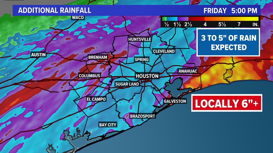
HOUSTON — Three to five inches of rainfall over the next couple of days could lead to high-water spots in some areas heading into Easter weekend, according to the KHOU 11 Weather Team.
Storms are headed toward the Katy area late this morning. Expect downpours, gusty winds, and the chance for hail. Another round of heavy rain is possible tomorrow morning.
Rainfall totals continue to pile up in the communities northwest of the Houston metro area as the heaviest storms pass through. Some isolated areas have seen over 6".
According to Harris County Meteorologist Jeff Lindner, 24-hour totals for western Montgomery County range from 6 to 7 inches of rainfall.
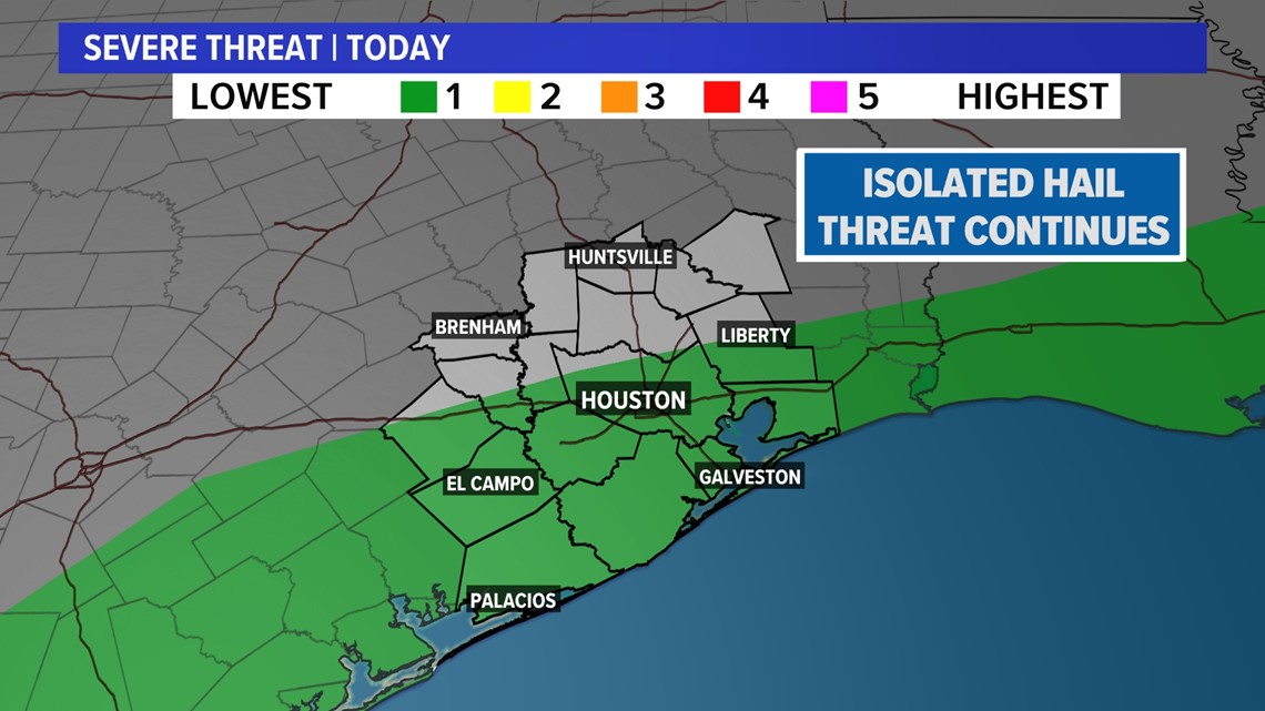
Hail in Houston: Quarter to golf size-ball hail falls in Richmond, Katy areas
Active weather alerts
There are no active weather alerts at this time.


What you need to know
- Three to five inches of rain is possible in some areas between Thursday and Friday
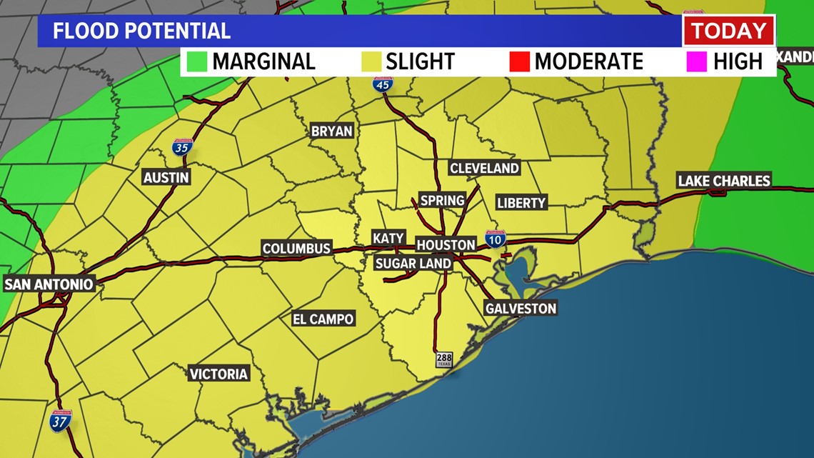
- Scattered downpours could lead to high-water spots, especially in areas already saturated.
- Temperatures are expected to be significantly cooler heading into Easter weekend.
- For Easter Sunday, the weather is expected to turn drier, with an isolated chance for a few showers, mainly in the morning.
Stay weather smart today. Get the KHOU 11 app to get alerts when severe weather watches and warnings are issued for your part of town. We'll be live throughout the day on KHOU 11+, which you can get for free on Roku and Fire TV.
Helpful links
Weather Houston, Texas radar
Track the rain with our live radar stream below.
What is a severe thunderstorm warning?
According to the National Weather Service, a Severe Thunderstorm Warning is issued when a severe storm is happening or is imminent. You're going to want to take shelter immediately. Check the local forecast for updates as conditions can change rapidly.
Thunderstorms can produce strong winds, lightning, hail storms, and tornadoes.
If you see lightning, try using the "30-30 Rule," which means after you see lightning, start counting to 30. According to the CDC, if you hear thunder before you reach 30, go indoors. Once you're indoors, keep listening for the thunder. If you hear the next boom 30 secinds after the first, stay inside.
What is a severe thunderstorm watch?
According to the National Weather Service, a Severe Thunderstorm Watch is issued when severe storms are possible in the near future. It's important to stay tuned to the local forecast and monitor sky conditions. Know where to take shelter.
What is a flash flood warning?
According to the National Weather Service, a Flash Flood Warning is issued when flooding is happening or will happen soon. If you're driving along an area of high water, seek higher ground immediately. As always, be sure to remember this rule: Turn around. Don't drown.
What is a flood watch?
According to the National Weather Service, a Flash Flood Watch is issued when flooding is possible. It's important to stay tuned to the local forecast and be ready to seek higher ground if needed.
What is a flood advisory?
According to the National Weather Service, a Flood Advisory is issued when a specific weather event that is forecast to occur may become a nuisance. A Flood Advisory is issued when flooding is not expected to be bad enough to issue a warning. However, it may cause significant inconvenience, and if caution is not exercised, it could lead to situations that may threaten life and/or property.

The Harris County Flood Control District's Flood Warning System and alerts are easy ways to monitor conditions.
What to do during flooding?
Flooding is a common experience in the Houston area. It's important to know if you're in a flood-prone area and be prepared for flooding before it happens.
If you're in an area that is experiencing heavy rainfall and you see water rising:
- Get to higher ground
- Do not drive into water
- Stay informed
Since Houston is no stranger to flooding, it's important to know the difference between a flood watch and a flood warning.
We have seen flooding events devastate Houston communities. The best way you can help your neighbors during a flooding event is:
- Plan an evacuation route before the water gets too high
- If flooding is expected, help others get to elevated areas
- After storms, check on your neighbors and keep others out of floodwaters
Floodwaters can contain chemicals, sewage and disease.
Be careful if you need to walk through floodwaters because there could be debris and sharp objects that can cause injury.
What do the severe weather threat levels mean?
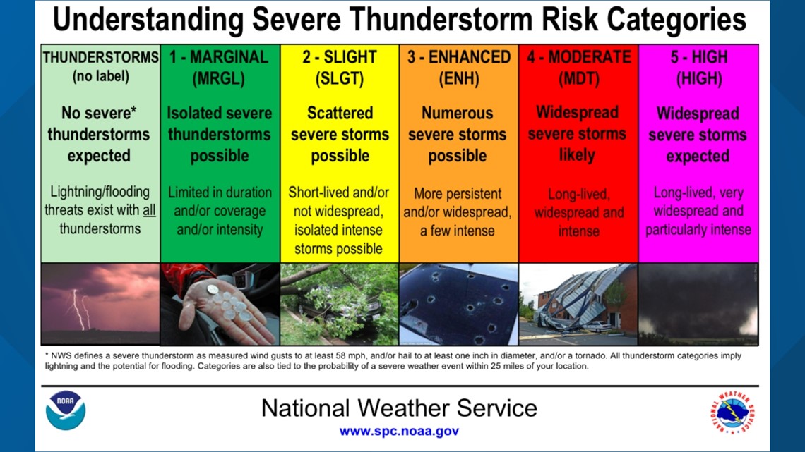
Severe thunderstorm risk categories
In order of risk and severity, here are the five risk categories and what each of them means, according to the SPC:
- Marginal (Dark green): This initial level means isolated severe thunderstorms are possible. Storms would likely be limited in how long they last, how much area they cover and how intense they become.
- Slight (Yellow): A slight risk means scattered severe storms are possible, though they'd likely be short-lived and not have widespread coverage over an area. While they might not be as persistent, these storms could still produce isolated intense conditions.
- Enhanced (Orange): Under enhanced conditions, numerous severe storms are possible. This level is marked by more persistent and widespread storms, a few of which could be intense.
- Moderate (Red): Jumping to a moderate risk level means more widespread severe storms are likely, and they could be long-lived and intense.
- High (Magenta): An area where a severe weather outbreak is expected from either numerous intense and long-tracked tornadoes or a long-lived derecho-producing thunderstorm complex that produces hurricane-force wind gusts and widespread damage. This risk is reserved for when high confidence exists in widespread coverage of severe weather with embedded instances of extreme severe (i.e., violent tornadoes or very damaging convective wind events).

Latest weather updates
The KHOU 11 Weather Team is working to keep you updated as the latest information becomes available:
Thursday, April 6
12:10 PM: Meteorologist Chita Craft says we're seeing a big split with the rainfall total of about .10 to 2 inches in town and 5 to 8 north of Houston.
11 AM: According to Harris County Meteorologist Jeff Lindner, 24-hour totals for western Montgomery County range from 6 to 7 inches of rainfall.
10:45 AM: Heads up Katy! Storms are headed your way. Expect downpours, gusty winds, and the chance for hail. Another round of heavy rain is possible tomorrow morning.
8:25 AM: According to Harris County Meteorologist Jeff Lindner, rainfall totals continue to pile up in the communities northwest of the Houston metro area.
8:05 AM: Meteorologist Chita Craft has an update on the timing of the heaviest downpours and the flood advisories.
7 AM: Deputies say a speed and wet roads led to a deadly crash in which a Conroe woman was thrown from her vehicle.
5:15 AM: Meteorologist Pat Cavlin says the best chances for rain will be focused north of the metro area before eventually spreading to the coast by this evening.
3:45 AM: Meteorologist Chita Craft says we have seen a 20-degree temperature drop since Wednesday so make sure to grab a jacket on the way out the day.
3:40 AM: Meteorologist Chita Craft says the strongest storms should remain north and northwest of the Houston metro area this morning.
Follow the KHOU 11 Weather Team for updates: