
HOUSTON -- Hurricane season has not yet begun and the last thing we want to think about is a big storm. 'Invest 90L' is making us pay attention this time.
Invest is short for 'investigational' and it's a term you may see a lot on KHOU 11 News and KHOU.com. It's a naming style used by the National Hurricane Center to describe an area they are monitoring for potential future development.
The latest one now has a 60 percent chance for development in the Gulf of Mexico in the next five days, according to the National Hurricane Center.

As of this writing, those computers are keeping the center of whatever forms closer to New Orleans than us. That would place us on the dry side and keep the heavy rain and flooding threat well off to the east of Houston/Galveston.
The last time we had a May land falling tropical storm was 'Beryl' in 2012. That one made for a soggy Memorial Day weekend along the Florida, Georgia and Carolina coast.
7 a.m. update from the National Hurricane Center
A broad surface low centered near the coast of northeastern Belize
continues to produce a large area of cloudiness and showers
extending from the northwestern Caribbean Sea across Cuba and into
the Florida Straits. Little development is expected during the
next couple of days due to strong upper-level winds and proximity to
the Yucatan Peninsula. However, environmental conditions are then
forecast to become more conducive for development, and a subtropical
or tropical depression could form this weekend over the eastern or
central Gulf of Mexico. Regardless of development, locally heavy
rainfall is possible across western Cuba and the Cayman Islands
during the next few days, and over much of Florida and the
northern Gulf Coast during the weekend. For more information on the
heavy rain threat, please see products issued by your local weather
office. The next Special Tropical Weather Outlook on this system
will be issued by 800 PM EDT.
* Formation chance through 48 hours...low...near 0 percent.
* Formation chance through 5 days...medium...60 percent.
Beach bummer? Tropical storm could drench eastern Gulf Coast over Memorial Day weekend
The unofficial kickoff to summer could have an unwelcome visitor this weekend.
If it forms, it would be the season's first named storm and would be called Alberto.
"Some gradual subtropical or tropical development is possible late this week while
the system moves slowly northward into the central or eastern Gulf of Mexico," the hurricane center said.
The system, currently located east of Belize in the Caribbean Sea, will slowly move north into the Gulf of Mexico and would approach land by late Saturday, according to the hurricane center.
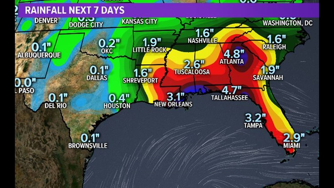
Locally heavy rainfall is possible in western Cuba, the Cayman Islands and much of Florida during the next several days.
AccuWeather meteorologist Dan Kottlowski said that "regardless of tropical or non-tropical development, this system will continue to produce heavy rainfall that will lead to flooding over parts of Florida and the Deep South and southeastern U.S. during the next several days."
Weather.us meteorologist Ryan Maue said to "prepare for a lot of rainfall all along the Gulf Coast beaches this weekend. Friday-Monday will be very wet. All 4 days will see substantial amounts."
The Florida governor's office said it was monitoring the system and encouraged Floridians to prepare "for significant rain and possible flooding."
The office said the Florida Fish and Wildlife Commission was pre-positioning the agency's high-water vehicles for rapid deployment if needed.
"Although the storm currently has a relatively low chance of development into a tropical system, we must take it seriously," Gov. Rick Scott said in a prepared statement.
A National Weather Service forecast said up to 5 inches of rain is likely in much of the Southeast over the next week.
Rain from the system will slowly invade the mid-Atlantic and Northeast through the weekend, with Monday, Memorial Day, looking to be the wettest day in those regions, AccuWeather said.
Some showers and thunderstorms from a separate weather system are also possible in the Northwest and northern Rockies through the weekend.
Most of the central U.S. will enjoy warm, dry weather, AccuWeather said.
Contributing: Melissa Nelson Gabriel, the Pensacola News-Journal