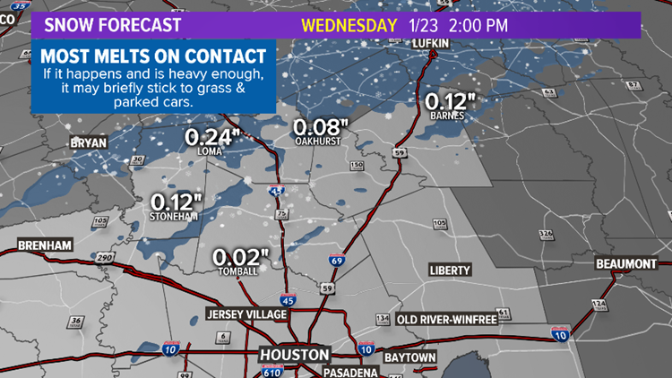
HOUSTON — I'll say right off the bat: I'm not expecting much for Houston, if anything out of this one. But ... there is a chance we'll catch a few snow flakes north of the city. I know that's not the best way to sell it but if I'm going to sell anything to you, I'm going to tell you what's in the box. That said, so many of us love the rare novelty of snow so this is an exciting potential. The reality is that we're most likely to face a cold and windy Wednesday morning with nothing more than lingering, bone-chilling rain showers ... If it does mix with or turn to snow, a brief coating could accumulate on elevated surfaces (grassy areas, parked cars) for a short time in a few spots north of Montgomery County -- about 45 min north of Houston -- before melting. I don't think we'll see much of anything in the metro but if you happen to venture a bit farther north, a lucky bunch may pick up a taste of winter's touch.
Temperatures will remain above freezing so even if snow does fall heavily, it won't stick to the roads or sidewalks. If it accumulates at all, it'd tend to melt away within an hour.
TIMELINE OF COLD FRONT
- 11 PM TUE - 62° - Showers and storms
- 2 AM WED - 43° - Showers lingering
- 5 AM WED - 39° - Showers lingering, may mix with snow far NW
- 8 AM WED - 38° - Showers lingering, may mix with snow NW counties
- 11 AM WED - 39° - Showers dissipate and head toward the coast.
- 2 PM WED - 41° - Sun starts to come out and precip ends
- Meteorologist Brooks Garner - follow me on Insta and FB!