
HOUSTON — The National Hurricane Center is monitoring a number tropical systems/disturbances as the peak of the Atlantic hurricane season continues.
Among those are Tropical Storm Paulette and Tropical Storm Rene, which are not a threat to land.
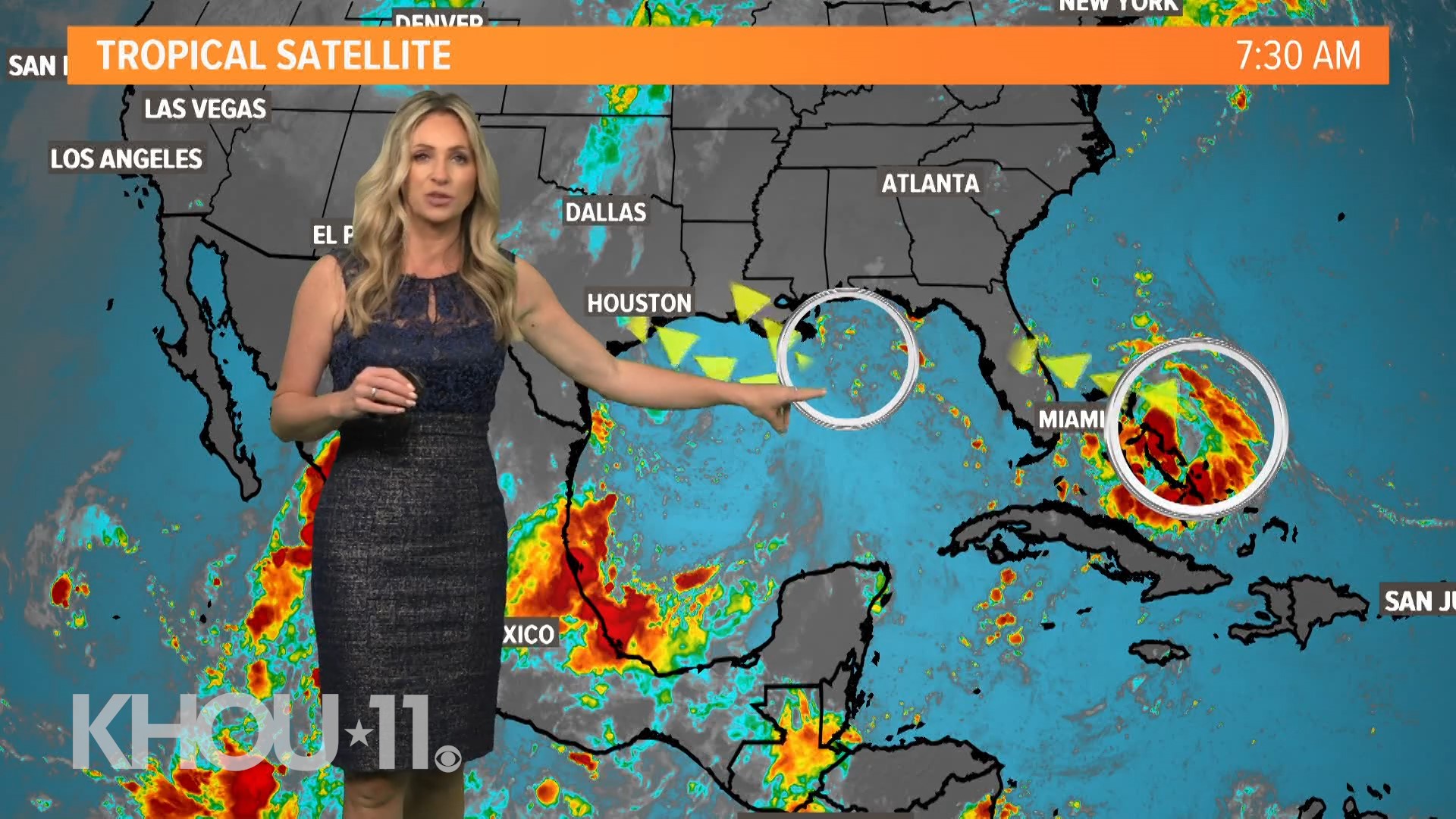
Getting the good news out of the way first, there are no foreseeable serious threats to the Gulf Coast at this time, although we could get some extra downpours early this coming week due to a disturbance in the Gulf of Mexico.


As of Friday morning, the disturbance in the Gulf only has a 10% chance of development, but even if it doesn't strengthen it'll bring rain and gusty winds. Houston has a good chance for scattered downpours next week, nearly the entire week.
HOUSTON WEATHER: View local forecast now
Out in the open Atlantic, we are monitoring Paulette and Rene. They are not expected to interact with land. You can track Paulette and Rene below:
Here are the latest details on all these systems for the morning of Sept. 11, 2020 from the National Hurricane Center:
The National Hurricane Center is issuing advisories on Tropical Storm Paulette, located over the central tropical Atlantic, and on Tropical Storm Rene, located over the eastern tropical Atlantic.
1. A surface trough of low pressure located over the northwestern Bahamas is producing a large area of disorganized showers and thunderstorms that extend from the northwestern and central Bahamas eastward a few hundred miles over the western Atlantic. This system is forecast to move westward at about 10 mph, crossing the Bahamas and Florida today and tonight and moving into the eastern Gulf of Mexico on Saturday. Upper-level winds are expected to become conducive for development, and a tropical depression could form while this system moves slowly west-northwestward over the eastern Gulf of Mexico this weekend and early next week. Regardless of development, this system is expected to produce locally heavy rainfall over portions of the Bahamas, South Florida, and the Florida Keys during the next couple of days. * Formation chance through 48 hours...medium...40 percent. * Formation chance through 5 days...medium...60 percent.
2. Another trough of low pressure is located over the north-central Gulf of Mexico. Although the associated shower and thunderstorm activity is currently minimal, some slow development of this system is possible while it moves westward and then southwestward over the northern and western Gulf of Mexico through early next week. * Formation chance through 48 hours...low...10 percent. * Formation chance through 5 days...low...30 percent.
3. A tropical wave is located a few hundred miles south of the Cabo Verde Islands and is producing a large area of disorganized showers and thunderstorms. Development of this system is forecast, and a tropical depression is expected to form within the next few days while the system moves generally westward at 15 to 20 mph across the eastern and central tropical Atlantic. * Formation chance through 48 hours...high...70 percent. * Formation chance through 5 days...high...90 percent.
4. Another large area of disturbed weather associated with a tropical wave is beginning to move off the west coast of Africa. Environmental conditions appear conducive for development during the next few days, and a tropical depression could form over the far eastern tropical Atlantic early next week while the system moves slowly westward. Upper-level winds could become less conducive for development by Monday or Tuesday. * Formation chance through 48 hours...low...10 percent. * Formation chance through 5 days...medium...40 percent.


HURRICANE SUPPLIES
It's already been a busy Atlantic hurricane season and now is the time to get ready, just in case Laura comes our way.
Here are some of the items you'll want to have on hand if a storm comes our way.
- Water: at least 1 gallon daily per person for 3-7 days; also fill bathtub and other containers; Gatorade is good to fend off dehydration
- Food: at least enough for 3-7 days; non-perishable packaged or canned food; juices; foods for infants or elderly family members; snack foods; food for special diets
- Non-electric can opener
- Cooking tools, fuel
- Paper plates and cups, plastic utensils
- Bedding: Blankets, Pillows, etc.
- Clothing
- Rain gear
- Sturdy shoes
- First aid kit, medicines, prescription drugs
BEFORE THE STORM
- Make a home inventory
- Have a current copy of your declarations page that has your policy number and your agent's number
- Review your policy with your insurance agent to determine if you have adequate coverage
- Repair loose boards, shingles, shutters and downspouts to prevent them from becoming an issue in high winds or torrential rain
- Have an evacuation plan, and include plans for your pets
- Make sure your emergency equipment is in working order, including a battery-powered radio, flashlights and extra batteries. Also, make sure to gather all medicine, replenish your first-aid kit and stock a week's worth of non-perishable food and water
- Charge your cell phone and fill your car with gas
- Program all emergency phone numbers
DURING THE STORM
- If you are advised to evacuate, leave as soon as possible. Retain all related receipts - they may be considered in your claim. If you aren't in a recommended evacuation and you plant to stay home, stay informed by listening to weather alerts
- Keep windows and doors closed at all time, and, if possible, board them up with wooden or metal shutters
- Stay away from the windows and in the center of the room, or, stay in an interior room
- Avoid flood water, as it may be electrically charged from downed power lines
- Check on family members and friends
AFTER THE STORM
- Check to be sure your family members are safe
- If you did evacuate, wait for official notice that it is safe to re-enter your neighborhood and your house
- Document damaged property, and take photos and videos. Don't dispose of any damaged items without approval
- Keep a record of any temporary repairs or expenses to prevent further damage to your property