
HOUSTON — Forecasters at Colorado State University released their preseason Atlantic Hurricane season outlook on Thursday.
The outlook calls for a slightly below average season.
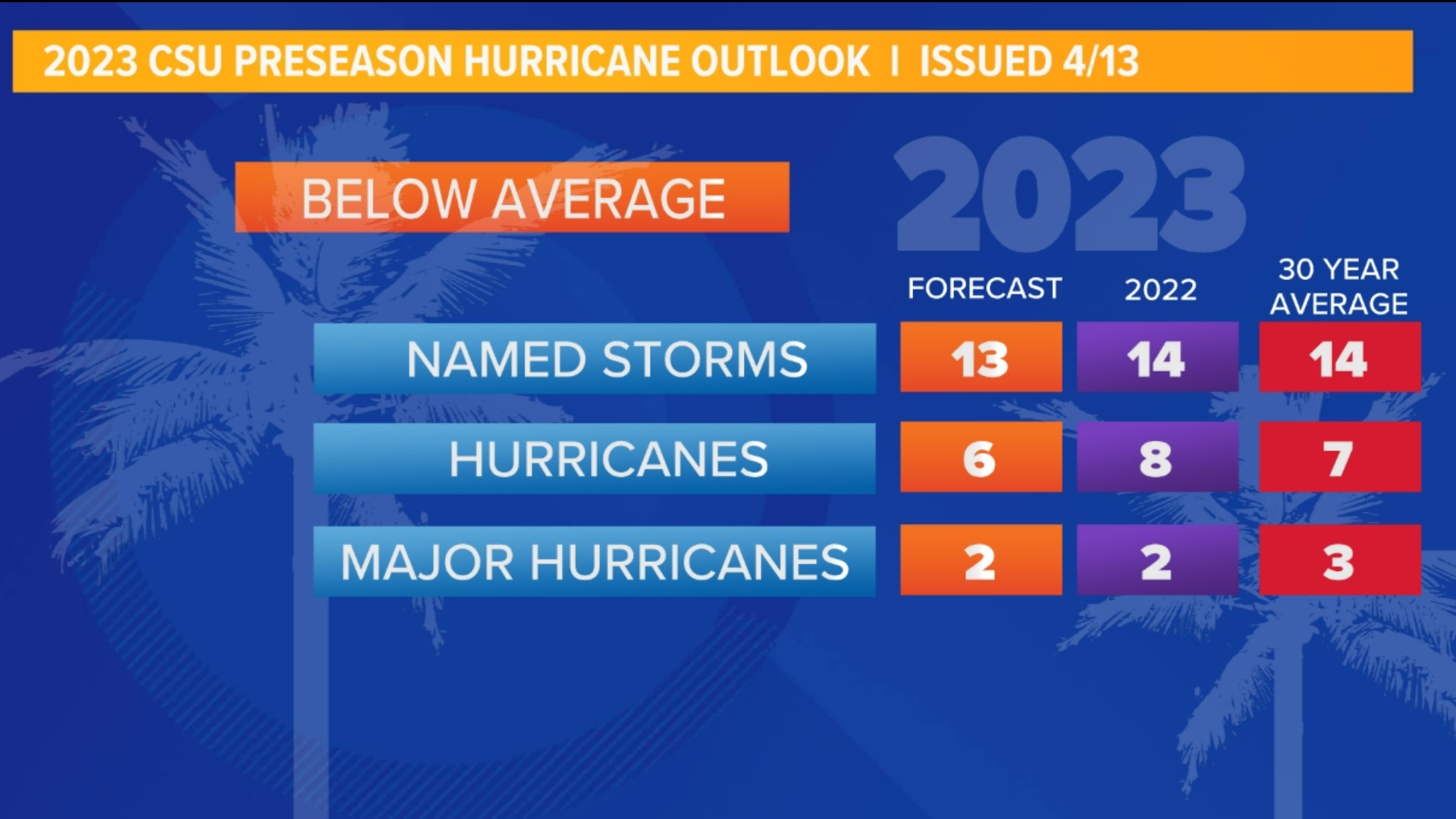
Average, based on the past 30 years, consists of 14 named storms, 7 hurricanes and 3 major hurricanes.
The April 13 outlook from Colorado State calls for 13 named storms, 6 hurricanes and 2 major hurricanes.
The reasoning behind the slightly less active seasonal outlook lies with the development of an El Niño, warmer than average ocean temperatures off the Pacific coast of South America.
This is a major shift after 3 years in a row of La Niña conditions (cooler than normal ocean temperatures in that same region).
El Niño years are typically associated with suppressed hurricane activity due to an increase in wind shear. Wind shear is a change in wind speed and direction with height, this disrupts storm development when it is present.
Variability does exist however, mainly due to warmer than normal ocean temperatures throughout much of the Atlantic. This is fuel for developing storms. If wind shear is not present, there would be plenty of opportunity for storms to take advantage of the warmer waters and develop.
Other highlights to the report are landfall chances for the U.S.. The CSU forecast paints a 44% that the U.S. coastline is hit by a major (cat. 3+) hurricane. Slightly lower odds for the Gulf Coast at 28% chance.
CSU will update this outlook at the start of the season on June 1.
What is El Niño?
El Niño phases are the opposite of La Niña. Warmer sea surface temperature anomalies replace the cooler ones in the equatorial Pacific waters off the coast of South America. Warmer waters lead to increased rising motion and convection. An increased occurrence of wind shear develops downstream of this convection leading to a more hostile environment for tropical systems. El Niño’s are typically connected with lower hurricane activity in the Atlantic basin.
Now, sure hurricane season activity has importance for southeast Texas, but what about our overall patterns during an El Niño or La Niña, what changes?
Well, what we’ve experienced the last 3 years is a retracted jet stream, or storm track to our north. This leaves Texas in a drier, warmer pattern with ridging prevailing. Just take a look back at this past summer: A prolonged, damaging drought and multiple triple-digit heat waves.
During an El Niño year we typically see that storm track diving farther south, delivering a wetter overall pattern and somewhat cooler as well.