
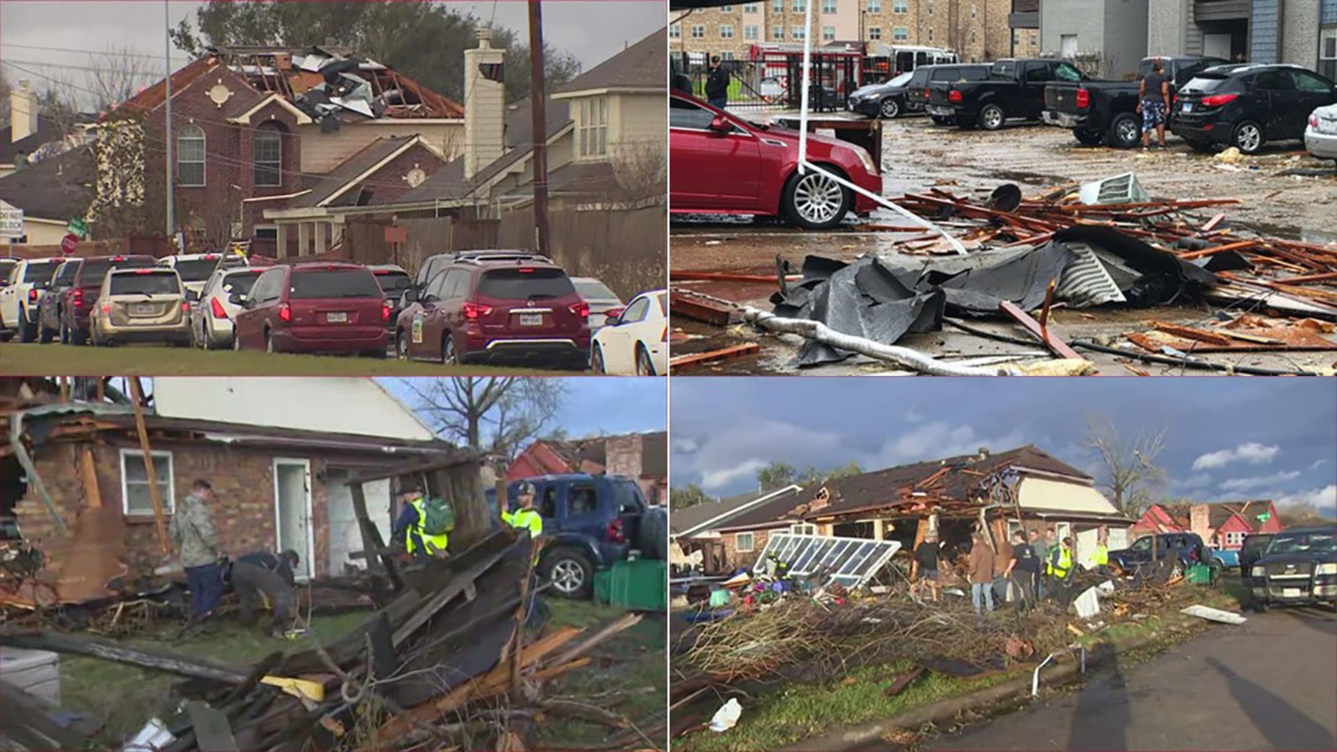
HOUSTON — Severe weather pushed through Southeast Texas on Tuesday, bringing strong wind, at least one tornado and several high-water locations across the Houston area.
Stay weather-smart. Get the KHOU 11 app to get alerts when severe weather watches and warnings are issued for your part of town. And we'll be live throughout the day on KHOU 11+, which you can get for free on Roku and Fire TV.
TIMELINE: The timing of the severe weather.
What you need to know
- The strongest of the storms were in the Houston area between 10 a.m. and 5 p.m.
- In the early afternoon, a squall line developed along the incoming cold front, which produced damaging winds and at least one tornado.
- Wind gusts from 30 to 50 mph were reported across the area.
- With the strong wind gusts, things were blown around and high-profile vehicles were flipped. Damage was also reported to property.
- Some areas saw heavy rainfall amounts of 1 to 3 inches with isolated areas getting about 6 inches.
Helpful links
Updates:
Tuesday, Jan. 24
6:45 PM: Deer Park officials said a nursing home was damaged and seven people were taken to an area hospital for evaluation.
6:30 PM: The Pasadena Salvation Army is setting up a relief station at the corner of Burke & Yellowstone. Meals and assistance information will be provided on the scene.
5:07 PM: Flights to George Bush Intercontinental Airport are being delayed an average of 128 minutes (2 hours and 8 minutes) due to thunderstorms. This delay is for all departures within 1,400 nautical miles.
4:30 PM: The Pasadena Animal Shelter sustained significant damage when a tornado passed through the area. The animals were safe but 70 of them were being taken to another facility.
The Pasadena mayor said one injury was reported.
3:20 PM: Severe Thunderstorm Warning issued for Brazoria, Chambers and Galveston counties until 4 p.m.
3:15 PM: The Texas Department of Transportation reports that there is a damaged overhead sign on I-69 Southwest Freeway southbound between SH 99 and Williams Way. Crews will close a few entrance ramps and a lane in 69 southbound at SH 99.
3 PM: From the Pasadena Police Department:
"We are aware of a tornado touching down on the southeast side of our city. Our officers and Fire Department are working towards assisting those people with who were immediately affected.
"Please note that we have dozens of calls coming in and that there will a longer then expected wait time. We will update everyone as soon as we have further information.
"Power lines are down at Burke and Parkridge, please avoid the area. We also have reports of several commercial trucks overturned in the area near Beltway 8 and Fairmont and Beltway 8 and Vista."
2:55 PM: Clear Creek ISD reports that students are safe after a Tornado Warning was issued. Impacted schools are sheltering in place until the warning has been lifted, which should be soon.
2:50 PM: Harris County Sheriff Ed Gonzalez tweeted a few more high-water spots - 19739 Mountain Dale, 14499 Telge, Doerre Middle School (Klein ISD), 15100 Ripplewind Ln (water going in a house), and Wood Forest/Uvalde.
2:45 PM: Tornado Warning issued for parts of Harris and Liberty counties until 3 p.m.
2:30 PM: Tornado Warning issued for Harris, Chambers, and Liberty counties until 3 p.m. Tornado on the ground near Gulf Freeway just south of Pasadena.
This tornado is heading towards the Baytown area.
2:15 PM: Tornado Warning issued for parts of Harris and Brazoria counties until 2:30 p.m. Those near Pearland and Brookside Village take shelter. Tornado warning issued. Spotter reports of a tornado in the area.
2:05 PM: Severe Thunderstorm Warning issued for Harris, Fort Bend, Galveston, Brazoria and Matagorda counties until 2:30 p.m.
2 PM: Harris County Sheriff Ed Gonzalez reports high water at these locations - Greenhouse and Tuckerton; 3900 Gladebrook Court; and Keith Harrow at Pebbles.
1:45 PM: Tornado Warning for parts of Fort Bend and Brazoria counties until 2 p.m.
1:35 PM: South Montgomery County Firefighters have just completed a water rescue on Sawdust Road, according to the Montgomery County Fire Marshal's Office. Flash flooding is occurring in some low-lying areas.
1:25 PM: Severe Thunderstorm Warning issued for Harris, Fort Bend and Wharton counties until 2 p.m.
Fort Bend ISD has canceled all after-school activities due to inclement weather.
1:15 PM: Flash Flood Warning issued for Fort Bend, Austin, Waller and Wharton counties until 3 p.m.
1:10 PM: Galena Park ISD said, out of an abundance of caution, the district is canceling all after-school activities, events, meetings, and night school today, due to anticipated inclement weather in our area.
1:05 PM: Storm Chaser Houston @PastorJaimeG sent us this video of heavy downpours in the Sealy area in Austin County. They're under a flash flood warning until 3 p.m.
12:50 PM: A KHOU 11 crew spotted a car stuck in a high-water spot in the Katy area.
12:40 PM: Spring Branch ISD schools and facilities are sheltering in place due to weather conditions in the area. Please monitor our website and social media for updates.
12:35 p.m.: Due to inclement weather conditions, the Houston Zoo will close early at 1 p.m. and plans to reopen on Wednesday. Guests who have purchased tickets for today can reschedule for another day of their choosing by emailing group.reservations@houstonzoo.org.
12:30 PM: Severe Thunderstorm Warning issued for El Campo, Edna and Ganado until 1 p.m.
Tornado Warning issued for parts of Harris, Fort Bend and Waller counties was allowed to expire.
12:15 PM: Tornado Warning issued for parts of Harris, Fort Bend and Waller counties until 12:45 p.m.
Cinco Ranch High School in on lockdown due to the severe weather.
NOON: Severe Thunderstorm Warning issued for Fort Bend, Colorado, Wharton, Austin and Waller counties until 12:15 p.m.
11:50 AM: Klein ISD reports that tornado warnings are affecting multiple areas in the district. Out of precaution, all students and staff have been moved inside the buildings and are sheltering in place according to their inclement weather procedures.
Waller ISD is also sheltering in place due to the severe weather.
11:35 AM: Tornado Warning was issued for parts of Harris and Montgomery counties until noon. This is in the Cypress area.
This dangerous storm will be near Willowbrook around 11:45 a.m. Tomball and Hooks Airport around 11:50 a.m. Spring around 11:55 a.m.
11:25 AM: Tornado Warning issued for parts of Colorado, Austin and Waller counties until noon.
11:20 AM: All Houston ISD after-school activities are canceled today due to inclement weather
11:05 AM: Tornado Warning issued for Harris, Fort Bend, Waller and Austin counties until 11:30 a.m.
10:50 AM: Severe Thunderstorm Warning issued for parts of Harris, Fort Bend, Waller, Austin, Wharton, and Colorado counties until 11:15 a.m.
10:40 AM: A Tornado Warning has been issued for parts of Lavaca County until 11 a.m.
10:30 AM: Meteorologist Tim Pandajis says a Tornado Watch will likely be issued in the Houston area within the hour.
10:10 AM: A Severe Thunderstorm Warning was issued for Dewitt, Gonzalez an Lavaca counties until 10:30 a.m.
8:55 AM: The National Weather Service has issued a special weather statement for El Campo, Ganado and Louis until 9:30 a.m.
7:55 AM: Early morning showers have already made for slick roadways during the rush commute.
Monday, Jan. 23
8:30 PM: Houston ISD said it is monitoring the weather conditions, but nothing announcements have been made yet.
What is a tornado warning?
A Tornado Warning is issued by the local NOAA Office meteorologists who monitor the weather in the area. NOAA said they issue a warning when a tornado has been reported by spotters or indicated by radar and there is a serious threat to life and property in its path. During a tornado warning, you should act right away to find safe shelter.
What is a tornado watch?
During a Tornado Watch, tornadoes are possible in and around the watch area, according to NOAA. This means it is a good time to review your emergency plans. It is important to act quickly if a tornado warning is issued and if you spot one coming.
What to do during a tornado
When a tornado warning is issued, it is important to act quickly, according to NOAA.
If you are home, be sure to go to a safe room or an interior room away from windows, which could get blown out.
If you are in a workplace or school, be sure to follow your tornado drill instructions and head to your shelter location. Again, stay away from windows. NOAA also advises against going into large open rooms like a cafeteria or gymnasium.
If you are outside, seek shelter inside a sturdy building. NOAA said to avoid sheds and storage facilities.
If you are in a vehicle, you are advised to drive to a sturdy shelter. If you are not able to get to a shelter, get down into your car or abandon it and head to a low-lying area like a ditch.
What are the signs of a tornado?
Some tornadoes form without any warning, so it is important to know what to look for. According to NOAA, these are the signs to look for:
- Strong, persistent rotation in the cloud base.
- Whirling dust or debris on the ground under a cloud base -- tornadoes sometimes have no funnel!
- Hail or heavy rain followed by either dead calm or a fast, intense wind shift. Many tornadoes are wrapped in heavy precipitation and can't be seen.
- Day or night - Loud, continuous roar or rumble, which doesn't fade in a few seconds like thunder.
- Night - Small, bright, blue-green to white flashes at ground level near a thunderstorm (as opposed to silvery lightning up in the clouds). These mean power lines are being snapped by very strong wind, possibly a tornado.
- Night - Persistent lowering from the cloud base, illuminated or silhouetted by lightning -- especially if it is visually in ground contact or there is a blue-green-white power flash underneath.