HOUSTON — We started Wednesday in the 70s across the Houston area, but believe it or not a cold front is moving through that will drop our "feels-like" temperatures into the 30s by Thursday morning, says KHOU 11 Meteorologist Chita Craft.
RADAR MAP: Track showers in the Houston area, tap here
Expect light, scattered showers today around lunchtime through the afternoon as this front pushes through.
Here's a quick look at what you can expect.
Houston weather timeline
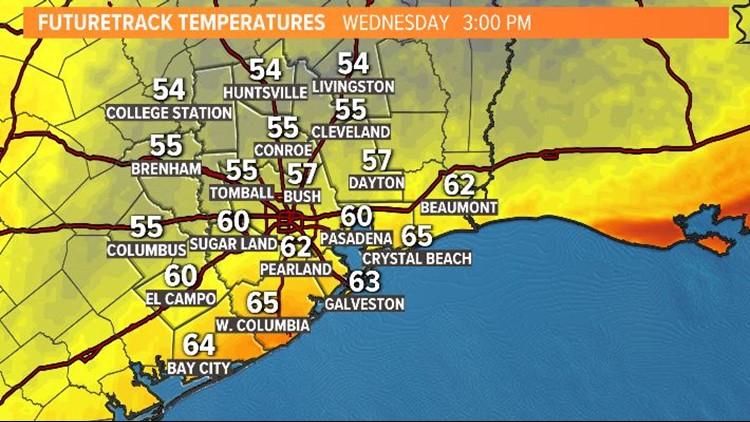
WEDNESDAY AFTERNOON: We started warm and humid in the 70s. Expect big changes this afternoon with temperatures dropping to the 50s with wind gusts around 40 mph. A cold front that started moving into our NW communities around 9 a.m. will push offshore around 3 p.m. Around lunchtime, we will have the best chance for rain. These will not be big downpours, however.


This afternoon, feels-like temps could be in the 40s with actual temps in the 50s. No rain is expected after 6 p.m. as the skies clear.
THURSDAY MORNING: The first day of April, but can you believe it we will have temperatures that feel like the 30s? Actual temps will be in the upper-40s to the low-50s across our area in the early-morning hours. No rain chance. Cool, clear and sunny — temps will stay in the 50s until almost lunchtime.
THURSDAY AFTERNOON/NIGHT: We will top out in the upper-60s and low-70s across the area, dry conditions continuing.
THIS WEEKEND: Temps will warm slightly but still stay in the 60s and 70s on Friday, Saturday and Sunday. We'll see sunshine again Friday, but clouds and a slight rain chance return for the weekend. Overall it will be mild — not worth cancelling outdoor plans, but just be prepared for a shower or two just in case.