WWLTV is streaming live weather coverage from Louisiana right now in the video player on this page
HOUSTON — It appears the Texas coast will be spared from any major impacts from Tropical Storm Cristobal, which is expected to make landfall today.
Our neighbors to the east in Louisiana and Mississippi will get the worst of it, leaving the Houston area and southeast Texas on the "dry side" of the storm.
When will Cristobal make landfall in Louisiana?
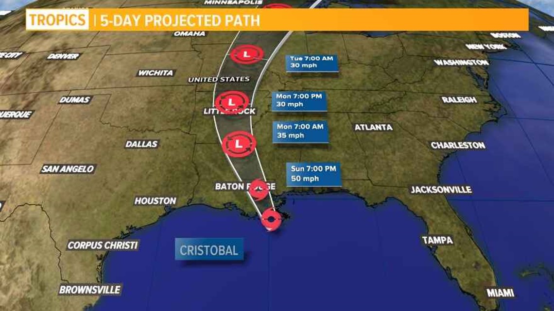
Tropical Storm Cristobal is bearing down on Louisiana and Mississippi. It is now expected to make landfall Sunday afternoon, bringing storm surge of several feet and more than 10" of rain in some areas.

While the heaviest rain appears to remain east of Louisiana, several parishes have issued evacuation orders for flood-prone areas. A tropical storm warning, flood warning and storm surge warning are in effect across the SE Louisiana parishes.
Heavy rains are expected to begin Sunday and continue into Monday, posing a severe flood threat in addition to the current coronavirus pandemic and civil unrest across the region.
Latest Cristobal advisory
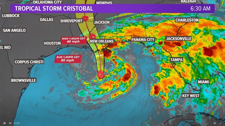
The 4 AM advisory from the NHC shows that not much has changed with Cristobal since earlier. Max winds remain at 50 mph and movement is northerly at 12 mph. The current position is 140 miles from the mouth of the Mississippi River. Landfall is still expected this afternoon near Cocodrie, LA.
The system remains very lopsided with most of the heavy rain and storms well displaced from the center. Very dry air seen on waver vapor imagery continues to to wrap around the southern side of the storm and into the center of circulation. This will keep the storm asymmetrical and rather disorganized today, but it's possible the storm becomes slightly more symmetrical by tonight or tomorrow as it moves closer to land. However, it's still unclear what result the dry will have on this storm. Right now, the dry air is keeping most of the thunderstorms displaced from the center and well east over the eastern Gulf and Florida.
Rainfall and coastal flooding are the main concerns. Winds are expected to pick up during the day and sustained around 30-50 mph with higher gusts especially near areas of water. This could cause some power outages.
Outer rain bands are moving across Southeast Louisiana this morning and they will increase in coverage as the day progresses. So far they have been brief tropical downpours, but anticipate more extensive heavy rain throughout the afternoon and tonight.
Flooding will threaten areas where rain bands set up today through Monday, and it is still unknown exactly where that may be. Rain totals between today and Monday night will be around 4-8" with some areas pick up 10"+. A Flash Flood Watch remains in effect until Tuesday morning for all of the viewing area. The Weather Prediction Center has highlighted the entire area for a high risk (Level 4 of 4) for flash flooding today.
Storm surge will arrive later this morning and continue into the evening as Cristobal makes landfall. Here is what is expected
- 3-5 feet between the Mouth of the Mississippi River to Ocean Springs, MS.
- 1-3 feet across Lake Pontchartrain.
- 2-4 feet from Morgan City to the Mouth of the Mississippi River
Rain bands will also bring the threat of weak tornadoes. The Storm Prediction Center has placed all of the area in a Slight Risk (Level 2 of 5) for tornadoes.